
.JPG)
Au revoir La Reunion!


Initially we had light winds then it picked up to 15-20knots. With boat speeds over 6 knots Eric pulled in the 1st Mahi Mahi. ( We only catch fish trolling at speeds greater than 5 knots)


On the 4th day at sea we had a great sunrise and sunset as we approached the south of Madagascar


Approaching the coast the wind increased to 30-35knots and gusting 40knots with big seas partially breaking at the stern. Running with the wind and seas with a boat speed of 8knots we encountered a deep “THUD” stalling “Erica” and scaring us to the max. There was no cracking sound and on inspection no obvious damage. We are pretty sure we hit a whale! It was near midnight and only starlit. The seas moderated as we came into the shelter of the land so we decided to seek shelter in Galion Bay where a thorough inspection was done at daybreak. With the moon just coming up we entered the anchorage cautiously. Putting the anchor down at 0230hrs.

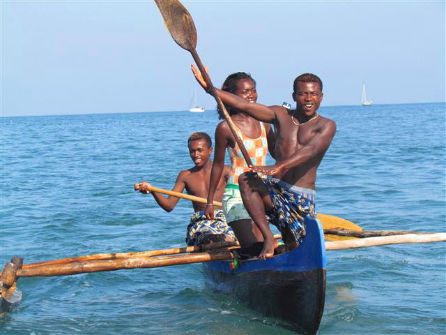
On daybreak Tagish arrived and we were both targeted by happy local Madagascans in canoes wanting to trade. We didn't go ashore but enjoyed the contact with the people from their canoes... As we speak no Madagasy, and only a few phrases in French, our communication was difficult but we got by with miming and drawing pictures. They were happy to receive fishing gear and clothes.

The landscape was majestic


The next morning our anchor and chain were snagged. We had a bad feeling when we anchored in the night. If we are uncertain of the sea bed we usually put a bouy on the chain to lift it off the bottom but didn't this time.. With 40m out and only able to pull 10m in we figured we were well wrapped around rocks. We manouevered the boat in all directions to try and uncoil it but to no avail.. The people don't seem to be divers and in 11m of water with poor visibility we decided to leave it as a souvenir!!
The scenery along the coast was
spectacular.

It was a slow trip as we had a counter
current of 1-2 knots, and some head winds, then no wind, but the next
2 days was an awesome treat as we watched humpback whales breaching,
rolling and tail flapping sometimes too close for our liking. The
closest was 2m from the side of the boat. They seemed to like diving
under us. We heard the whale song through the centreboard casing
initially and then it was so loud with orgasmic squeals and grunts we
could hear it in the cockpit. We found that when we put the motor on
they kept a greater distance from us


Cathy evened the fishing score by pulling in a nice sized Wahoo

On the 8th of October at 2330hrs we reached a long sandspit reef on the SW side of Madagascar and sought shelter tucked up behind it. Minorodo bay extends norwest from this.

We were greeted on daybreak with a canoe full of smiling men offering us a live chicken and eggs. We accepted the eggs and gave them half of the Wahoo we had caught.


For the next 2 days we thoroughly enjoyed the interaction with the people. They are so happy and grateful for anything one has to give them. Most sought after was fishing gear, diving masks, clothes,


They are extremely poor and have only what they get from the sea to trade .. We were offered crayfish, octopus, fish, shellfish, shells and even a land tortoise!

The people were insistent we went ashore so we took our backpacks full off gifts and had a canoe escort to the beach and village. They were singing and dancing along the way

We were welcomed on the beach by the village people. It was a most humbling experience

Their homes are very small and basic and constructed out of branches and scrub. There was no unnatural rubbish anywhere.


We were the honoured guests and were invited to sit on mats under some shade. Here we gave out gifts and tried to communicate the best we could. A few of the people brought out empty medicine packs wanting prescription drugs. These were medications for treatment of Tuberculosis. There appeared to be a lot of fungal skin rashes and oral thrush and they wanted anti fungal treatments for this. ( A consequence of longterm use of TB medication)


The children were asked to line up for Cathy to distribute sweets, but it was a mad shoving rush to get in before the rest. Each child did get one and Cathy sustained some scratches on her hands!
There were 150 sweets in the bag and they all disappeared!
It was very difficult to distribute gifts fairly so in the end we went to each dwelling and gave what we could.

This mother had very recently given birth so Cathy was in her midwifery mode cuddling the baby and giving the mum gifts.

After our packs were empty we took a walk through the village and along the beach with an entourage of children and young adults


The camera was a highlight and everyone wanted their photos taken. (I intended to process these and take them back to the village but we ran out of time and the wind came up in the night exposing the anchorage from the north, so we had to leave)

This elderly lady was given some reading glasses and Eric gave her a picture book which our German nephew had given us to aid communication during our travels

There were lots of interesting sights along the beachfront..Canoes being repaired and built, nets and fish sorted


We saw some goats. There must have been chickens somewhere but we saw none. This was a pen for the goats.


This oxen cart was headed off across
the bleak plains, apparently the road, with no sign of a driver

30mins or so later we saw him following after

The landscape is very barren with sand dunes, salt plains, scrub, cacti and the very occasional stunted tree.


We headed off back to our yachts for some lunch and a siesta, but the people kept coming out to visit so in the end we had to be firm and close up the cockpit shades and go below decks.


After 2 days of good sailing the wind
died to almost nothing so the motor got some use. The seas were calm
with hardly a ripple on the surface. The colours on the water at dawn
then later at sunrise were spectacular..It will never cease to amaze
us how quickly conditions change.


.png) ( High southerly winds with the strong nth to sth
flowing current can quickly push up steep and high waves ) We drifted in the direction we wanted to go at 2-3knots
( High southerly winds with the strong nth to sth
flowing current can quickly push up steep and high waves ) We drifted in the direction we wanted to go at 2-3knots.JPG)
We decided to head off again when it settled down but after 6 hrs we had to “Hove to” again with winds to 40knots kicking up the seas.

After 3 hrs we were on our way again and happy to see the dawn arrive. Cathy caught a flying fish on deck, followed by Eric so we breakfasted on fried fish and eggs

The last 40nm was amazing. We could see the land of Sth Africa through the haze. The Agulhas current pushed us along at an extra 3 knots. The seas were confused with waves forming peaks as the current opposed the swells and light breeze. We sure wouldn't want to have been there in high winds.
.JPG)


.JPG)
.JPG)
Well done Team “Erica”.
STH and SW Madagasdcar
Galion Bay
The anchorage is pretty accurate with the charting. We cautiously went in at dark. There is a rock to the west in the entrance so stay in the middle to east and all is good. Entrance line up waypoint (1) 25 09.599S 046 45.23E (2) 25 09.37S 46 45.15E Go beyond the next waypoint where the anchor is lost( 25 09.2123S 46 45.147E ) as we assume there is sand. There are local fishermen with nets set. The people desperately want clothing and fishing gear. The people we encountered did not want their photos taken without payment ( Maybe it is to buy back their souls from the church?) Galion Bay is well protected and a good jump off point to Richards Bay
Minorodo Bay.
Again we entered cautiously at night making a wide arc around the spit entrance. The charting was accurate.. Waypoint (1) 25 16.96S 44 17.3E (2) 25 15.40S 44 17.7E We anchored at 25 15.06S 44 20.7E in 4.8m with good holding sand. At daylight we anchored in further.. There are many choices. This anchorage is obviously exposed to westerly and northerly weather, but mostly the wind is from the Sth or east..The people are wonderful, happy but very poor living in shelters made of scrub and branches... They are free divers and want masks, flippers and rubber for their homemade spearguns and fishing gear. They also want clothes,toiletries, pens/pencils/books and food. The reef has abundant crays and octopus. Unlike Galion Bay there was no issue with taking photos. Infact they loved it. We had promised to take processed photos back in the next day but we had a wind shift in the night and had to leave the next morning with no time to do this.
Mansita
Island
We
did not anchor here but we have been told that there is shelter on
the NW side
Androko/
Tanilahy Bay.
We
entered in the daylight. We went between the island and long reef to
the divide between the reefs with heaps of clearance. Waypoint (1) 25
02.71S 44 01.99E (2) 25 02.05S 44 02.34E (3) We anchored at 25
02.15S 44 03.46E. There is plenty of depth further up to the sth until a sandbar protrudes from the land.The village is here but we had no visitors. There are plenty of places to anchor in 3-6m with a muddy and sand bottom. sheltering behind the reefs gives protection from the west. It is a long bay running from nth to sth so the waves could pick up with a blow from these directions but the holding is superb.
Richards Bay, Sth Africa
We left Androka bay, Southern
Madagascar in 25 ktns from the South with the knowledge that we could
expect this and more for 3 days followed by light winds from the
north for our approach to Richards bay .
We were informed by HF that the a
strong unforecast blow was developing below RB and we had to hove to
for 36 hours to let it pass.
We did not find the Agulhas current
until we were 28 miles from the coast and lost it again only 7 miles
off the coast. The wind was 8knts from the SE. The Agulhas current
showed signs of what might happen if there was more wind.
We arrived in the late afternoon at RB.
We found the port control a little difficult to understand on the
VHF. Apart from a few little anomalies we found our vector charting
to be good, as it proved to be elsewhere in SA.
On entering the small craft habour we
felt that we were heading into a restricted dead end.
It is not as bad as it seems. The
customs check in berth is in the far NE corner of the Small craft
habour between two concrete piers. All the berthage on these piers
was free with power and water.
We were encouraged to go into a berth
in the Tusi Gasi marina itself. (28* 47.675 S) (32*04.781E) In the
morning the marina staff were happy with that. Two days after arrival
the Customs and immigration casually checked us in.
As you are aware there are new issues
with staying in SA.
On entry we were told that were allowed
only a six month period that we could keep our boat in SA with out
paying a bond of 15% the value of our boat for temporary importation.
On leaving Cape Town a senior customs
official told us that they are also upholding this rule on the West
coast . Another six months may be granted for emergencies.
He also told us that you are not
suppose to leave you boat in SA. While you are elsewhere , with out
paying the 15% bond before you leave.
We stayed at Tusi Gasi and dried our
boat out on the ramp, grid, careening berth! This facility is
obvious as you exit the marina gates to your right. The boat names in
anti foul give it away.
We hired a water blaster from the
marine supply business directly across the road from the grid. The
grid was free and the blaster cost US$20. With our copper epoxy
bottom it was the cheapest haulage and anti foul we’ve had.
There are haulage facilities at Zulu
land YC. Also a good chandler.
We got a Vodacom SA network modem for
our internet and found that to be good.
Shopping for most things will mean a
taxi ride.
Locals will not encourage you to walk
for safety reasons. This held true everywhere else in SA as well.
The next step was watching for a break
to get south. A short break came but before we could leave RB we had
to complete formalities . For those who stay at the Zulu Land YC,
this means getting paper work from the YC filling it in and then
taking a walk over to see the police at the Tusi Gasi for an
approval stamp . Then returning the paper work to the ZLYC office.
If you have chosen to stay at TG , you must collect your paper work
from the office , fill it in and take a taxi to Customs, then another
taxi to Immigration , then back to the police at TG, then to the
stationer that is at TG to fax the said paper work to Port control.
After that you phone Port control to ask then to retrieve the said
paper work from the fax machine . Then you're set to go!


No comments:
Post a Comment