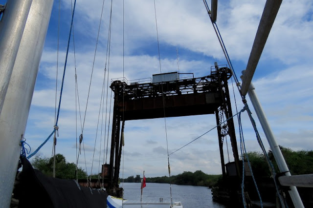
After two devastating hurricanes in 1927 and 1928, the Florida State Legislature created the "Okeechobee Flood Control District". The organization was authorized to cooperate with the U.S. Army Corps of Engineers in actions to prevent similar disasters. The Okeechobee Waterway is the result. Lake Okeechobee is enclosed by a 20-foot (6 m) high dike built by the U.S. Army Corps of Engineers (which replaced an earlier 6-foot mud dike) and incorporated the construction of channels, gates and levees resulting in a man-made waterway stretching from Fort Myers on the west coast, across (or around) Lake Okeechobee, to Stuart on the east coast of Florida. The waterway runs through Lake Okeechobee and consists of the Caloosahatchee River to the west of the lake and the St. Lucie Canal east of the lake.
The Port Mayaca RR Lift Bridge at Mile 38 has a 49-foot vertical clearance when open, which is thus the limiting vertical clearance for the waterway. Additionally, droughts periodically lower the water level of the lake sufficiently enough to limit its navigability. The US Army Corps of Engineers provides a daily update of water levels for both the cross-lake channel as well as the rim channel.
We took 3 days to navigate the waterway going under 27 bridges, some of these being swing bridges and bascule opening bridges and 5 locks.
Most of the bridges were 54-55' high
 The lowest was 49' We measured from the waterline to the top of the mast and it was 47.5' which meant we had a couple of feet spare but Eric thought it would be best to remove our wind direction and speed sensor and tri navigation lights from the top of the mast
As he was removing them we passed under power lines. Even though they were 88' high it was a bit unnerving knowing there was all that voltage up there
It was good experience in the locks for our future transit of the Panama Canal. The locks ranged from only 1' to 12'

We were able to download an information guide off the internet for the bridges and locks and "active captain" which is a boaters interactive information site had good information for anchorages.
We tied up to these Dolphins just before the Port Mayaca lock
Public dock at La Belle
We walked to a small grocery store to get supplies and enjoyed watching this squirrel eating acorns
For most of the trip we traveled unplanned with another yacht. We never officially got to meet the 2 men aboard but waved to each other along the way. It appeared that they were new to having a sailboat and we chuckled at the mistakes they made remembering our own mistakes when we started.
We chose to sail across the lake then entered the waterway again at Clewiston. This took us through a shallow channel with water lilies lining it.
Clewiston has gates to protect the town in the event of a Hurricane.

Many of the trees had Spanish moss hanging from them...Quite picturesque!
As we raced to get through this bascule bridge before nightfall we noticed this pretty lit up tree
There were great opportunities for photographs....We enjoyed watching birds and alligator.
Most dolphin tend to play at the bow of our boat but these ones kept coming up beside us in the cockpit and we got wet several times when they blew from their blowholes
After passing Fort Myers we were on the western coast of Florida and we anchored for the night at Shell point next to a floating bar/ restaurant
On Tuesday the 5th of January we set off to sea. It was lovely to feel the movement of sailing again.
This part of the coast is quite shallow. It was 5-7 metres deep , quite well off shore and there were a lot of crab pots we had to watch out for. The wind was 20-28 knots and predicted to get up to over 33 knots overnight so we decided to stop at Marco, 40nm down the coast and seek shelter.


3 comments:
Hello! My name is Debbie. I got to see you come through the Moore Haven lock. My boyfriend had told me that he was about 10 minutes behind you and in just a few minutes the lock operator and I spotted you going slowly on your approach. Then I heard on the radio that you had slowed down to wait for them. Thank you! My boyfriend (the bald fella with the goatee) & his brother in law said that they were with you guys for quite a way. I have a few pictures of you coming into the Moore Haven lock if you would like them. :-)
Great read, awesome photos :)
Hi Cathy and Eric, enjoying your photos and tales of your adventure. Thanks for the updates... wonderful
Post a Comment